


Our#: AM0745, ISBN: 0-929140-74-5, Scale: 1:60,000. Waterproof.
One of southern Canada's great wilderness rivers - the Spanish - is located northwest of Sudbury in Ontario.
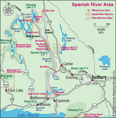
Our exceptionally-detailed 1:60,000 scale topographic map shows you the rapids, falls, swifts, campsites, portages, access points and other features of the East and West Branches from, respectively, Duke Lake and Biscotasi Lake in the north to Agnew Lake in the south. There are numerous access points to choose from, and one of the real treats of this route is taking the train, along with your canoe and gear, from Cartier or Sudbury north to your put-in.
The Spanish makes for a great introductory whitewater holiday (except in high water when more advanced skills are required), particularly the East Branch. The full-length East Branch trip starts at Duke Lake, for which you'll need to arrange a shuttle (your own or with a local outfitter), whereas shorter trips can start further south at The Forks, which is accessible by train.
The West Branch is a little more remote with more rapids to paddle so it is more suited to more experienced paddlers, but there are portages around every rapid so it's also a great "practicing whitewater" route. Easiest access is by train to one of many official points including the hamlet of Biscotasi at the top end, or Sinker Creek, The Forks, Sheahan, etc. further south.
Shorter trips on both branches often end at The Elbow where your car could be parked, but given time it's worth "doing" the entire route down to Agnew lake.
So there's something for every paddler, including sea kayakers who will enjoy Biscotasi Lake (and the big lakes on the Mississagi River side of the tracks) at the top end of the West Branch.
Everything you need to know is on our Adventure Map® guide - in addition to a detailed topo map and description of the route (including portage lengths and which side of the river they're on), we've also provided lots of info about the rich log drive history of the area, the plentiful animals, access options, local outfitters, safety concerns and much more. So get our guide. It has the answers to most of your questions. If it doesn't, we do, so give us a call!
–––––
One of the available images here is a simple map highlighting the area our guide covers, including the various access points, and also noting other Adventure Map® guides in the region. These include the closely-related Mississagi River/Aubrey Falls guide which shares the Biscostasing Access. Don't confuse the Mississagi River area with Mississagi P.P. & Area a little further south near Elliot Lake. It, too, is an exceptional paddling (and even better hiking) area. Halfway Lake Provincial Park offers a short, little-used backcountry paddling route as well as some great hiking trails with exceptional lookouts. Further south, on the south shore of Killarney Provincial Park is a popular sea-kayaking area covered in detail by our Philip Edward Island & Area guide.