


Our#: OM8840, ISBN: 0-7729-7884-0, Paper.
Note: This map is presently out of print but will be replaced in 2025 with an entirely new full colour version.
A large size, but small-scale (1:140,000) paper map of the entirety of the Temagami paddling area that is helpful for planning your trip. Covering all the official Ontario Parks in the area plus Conservation Reserves and Crown land, it shows basic water detail, access points, campsites, portages, and other points of interest, with trip planning guidelines and 23 route options described on the reverse side. This is a good general reference map for the entire Temagami area.
–––––
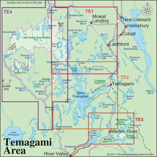
For larger-scale (features appear larger), much more detailed maps that are more suited to on-the-water navigation (but also trip planning for large parts of, but not the entirety of the Temagami area), you should get one or more of our major Temagami series - Temagami 1 - Northeast, Temagami 2 - Lake Temagami, Temagami 3-Marten & Temagami Rivers Area, Temagami 4- Northwest & Sturgeon River and our newest Temagami 5 - Chiniguchi. The heart of Temagami is fully covered by this series of 5 maps.
Not sure which of our Temagami Area maps you want? You can see how they all relate to each other using our Temagami Area Map Locator Guide. It's one of the images you can select on this page.