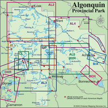
Buy all 4 of our major 1:60,000 scale Algonquin series (the largest scale, easiest to read Algonquin maps available) + our Close-ups + our Edge of Algonquin maps, at roughly 30% discount! Over $100 worth of essential paddling and hiking information for under $75. Our Algonquin 1-Corridor North, Algonquin 2-Northwest, Algonquin 3-Corridor South & Algonquin 4-North Central, plus the even larger-scale Barron/Achray area, cover almost the entire park in extraordinary large-scale detail with 4 additional maps providing great shorter stay or daytripping options (Canoe Lake to Tom Thomson Lake Close-up, Opeongo Lake Close-up) or edge of Algonquin river guides (Oxtongue and Bonnechere River).
That's 9 great waterproof maps with loads of essential and useful information on the reverse side (route descriptions, human and natural history, safety tips, weather, contact info, even moon & star charts on a couple, plus colour photos and illustrations). Take care of a lifetime or two of Algonquin trips in one fell swoop, or share your purchase with friends. And free shipping in Canada to boot!
Want just our main Algonquin guides? Then see our Algonquin Bundle A (5 maps) which includes our 4 major 1:60,000 scale Algonquin maps, plus the even larger-scale Barron/Achray guide to that area's compact wonders like the Barron Canyon, High Falls and water slides playground. That's more than enough for a few months of paddling and hiking getaways!
Not sure which of our individual Algonquin Area maps you want? Try our Algonquin Area Map Locator Guide - it's one of the images you can select on this page.


