• Welcome to our site • FREE SHIPPING in Canada for 2-3+ maps under total package weight of 500 grams • IMPORTANT NEWS: As you may be aware, the United States under U.S. Executive Order 14324, has suspended its duty-free de minimis (“disregard of trivial matters”) threshold of US$800 for all countries, including Canada. This order means that, starting August 29, 2025, all shipments entering the U.S. by post, courier, freight provider, or any commercial channel will be subject to an ad valorem (“according to value”) duty that must be prepaid before crossing the border. This duty will be equal to the effective tariff rate applicable to the product's country of origin (Canada in our case) under the International Emergency Economic Powers Act (IEEPA), a newly enacted old U.S. federal law. For Canada, the recently-assigned IEEPA rate is 35% for most goods. Unfortunately due to the onerous duties, declarations and paperwork involved required by this Executive order we will no longer be offering our products to either individual and business customers (only) in the United States. President Trump has repeatedly claimed that the Canada has “nothing” the USA needs. However, if you still wish to visit Canada for outdoor activities involving wilderness areas covered by our Adventure Map® series, we encourage you to seek out and purchase from a Canadian retailer after you cross the border. There is a list of such outlets on our website’s Where to Buy page. Call them in advance to ensure a copy is held for you to pick-up. And feel free to contact us if you have questions about the areas, maps or procedures • Best wishes •

Algonquin - Barron/Achray Map Cover
Algonquin Area Map Locator Guide
  • Load image into Gallery viewer, Algonquin - Barron/Achray Map Cover
  • Load image into Gallery viewer, Algonquin Area Map Locator Guide

Algonquin - Barron/Achray Close-up (AM015X)

Regular price
$9.95
Sale price
$9.95
Regular price
Sold out
Unit price
per 
Shipping calculated at checkout.

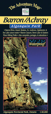
Our#: AM015X, ISBN: 0-929140-15-X, Scale: 1:40,000. Waterproof.

The dominant feature of this popular paddling, hiking and camping area on the east side of Algonquin Park is the 100-metre deep Barron Canyon, which you can enjoy from above at a great hiking viewpoint, or from below while paddling the River.

But there are other great attractions in this compact, feature-rich area, including High Falls, Brigham Chutes, the Barron River, old log drive relics and much more, all detailed on our large-scale 1:40,000 map.

The back side offers colour photos and textual descriptions about local flora and fauna, suggested routes, safety concerns and contact info. Also covers the Sec/Mallard Lakes area.

As usual, this 1:40,000 scale map provides extraordinary terrain and vegetation detail, as well as features campsites, portages, access points, hiking trails, facilities like campgrounds, telephones, historic sites, rental ranger cabins, and many more attractions. And, like others in the series, it's updated regularly and is waterproof.

_____

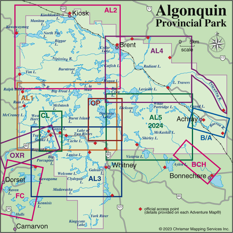
Also consider our other larger-scale Algonquin Close-up Maps of smaller popular areas (Bonnechere River, Canoe Lake & Area, and Oxtongue River) suitable for short trips of a week or less. Or try our larger area Algonquin guides (Algonquin 1-Corridor North, Algonquin 2-Northwest, Algonquin 3-Corridor South and Algonquin 4-Central North maps) suitable for longer trips or shorter ones in less-busy areas.

Not sure which of our Algonquin Area maps you want? Try our Algonquin Area Map Locator Guide - it's one of the images you can select on this page.