


Our#: OM001X, ISBN: 0-929140-01-X, Scale: 1:20,000. Paper (not waterproof).
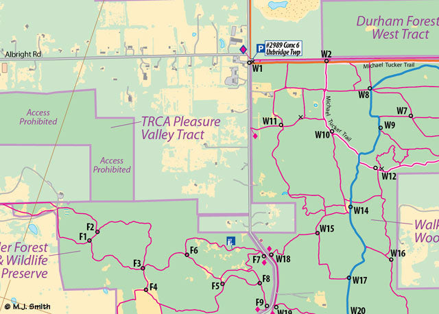
The Uxbridge South area in the Greater Toronto area's Durham Region encompasses the lands between Brock Road on the west and Lakeridge Road to the east, and from Goodwood Road (Regional Road 21) south to Concession Road 9. Local hikers may recognize that it covers the trail-rich conservation lands of Walker Woods, Wilder Forest, Glen Major, Durham Forest and Dagmar properties, among others.
But wait there's more...Just before starting the mapping process the focus was expanded northward to also include the area from Goodwood Road all the way up to Davis Drive, which means the town of Uxbridge itself, its Town Trail system and the Countryside Preserve are covered.
This is one detailed trip planning map, with almost every residence shown - over 5,500 buildings - and most business sites, over 25,000 individual trees and forest sections, 54 parks and conservation tracts, and nearly 300-kilometres of trails. And yet it is very clear and easy to read. The back side is covered with text and colour photographs describing the tracts of public land and the important features of each one from a trail users point of view. That includes access points, length of trails, wayfinding post numbers, and the name of the organization that manages the land.
In addition to this Overview Map to all the trails of Uxbridge South, there are 3 waterproof topographic "strip" maps covering each section in detail ideal for use in the field - the East "strip" includes Durham Forest Main Tract, Skyloft, Dagmar & others; the Central "strip" includes the Walker Woods and Glen Major areas, while the West “strip” includes the North Walker Woods, Wilder and Brock tracts. For a pleasant day hike or bike or cross-country ski or snowshoe with easy access and lots of services nearby, consider in the Uxbridge Countryside Preserve, a superb mixed forest and meadow hiking area right on the edge of Town.