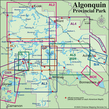
Our#: AM0559, ISBN: 0-929140-55-9, Scale: 1:50,000. Waterproof.
Opeongo is the largest lake in Algonquin Park, and plenty big enough for a week or more of canoe tripping. Other lakes on this 1:50,000 scale map include Happy Isle, Redrock, Proulx, Wright and Bonfield, as well as all the campsites, portages, facilities, fish species and other features you'd expect from one of our maps.
We've even indicated the routes of two of the first explorers through the area. The back side features colour photos and text about the area, including several recommended trips in the area.
_____
Also consider our other larger-scale Algonquin Close-up Maps of smaller popular areas (Bonnechere River, Canoe Lake, Oxtongue River and Barron-Achray) suitable for short trips of a week or less. Or try our larger area Algonquin guides (Algonquin 1-Corridor North, Algonquin 2-Northwest, Algonquin 3-Corridor South and Algonquin 4-Central North maps) suitable for longer trips or shorter ones in less-busy areas.
Not sure which of our Algonquin Area maps you want? Try our Algonquin Area Map Locator Guide - it's one of the images you can select on this page.


