Our#: AM0818, ISBN: 0-929140-81-8, Scale: 1:25,000. Waterproof.
This compact but feature-rich provincial park sits on the Canadian Shield about an hour north of Sudbury. Easily accessible by highway about 60 kilometres north of Sudbury, it has a fine combination of really great hiking trails, and an excellent, but surprisingly little-used, backcountry canoe route.
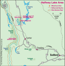
The simple map below provides an overview to the region. The main access point is on the west side of the highway leading to a very well-appointed 215-site campground on the picturesque north shore of Halfway Lake. Another access point further up the highway is dedicated to the Osprey Heights Trail. It is one of 4 excellent hiking trails between 2 and 15km-long, each with exceptional viewpoints.
The backcountry canoe route heads south from the Campground through a series of pretty lakes, then north up the west side of the park - it's quite isolated and quiet with large cliffs bordering the route (at the top end you can wave to anybody way above you on the Hawk Ridge Trail viewpoint). Alternatively, Halfway and Bailey lake (separated by just a 310-metre portage) are plenty big-enough for a sea kayaking excursion.
Our 1:25,000 large-scale topographic map is extraordinarily detailed, showing the campground, all trails, lakes, streams, wetlands, open areas and much more. The back side is filled with informative text and colour photographs about the natural and human history of the area, trail and canoe route descriptions, safety tips, contact info, and more. It's just about everything you need to know when planning and then taking your trip.


