


Our#: AM0893, ISBN: 0-929140-89-3, Scale: 1:65,000. Waterproof.
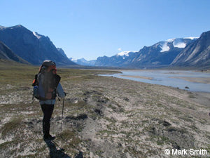
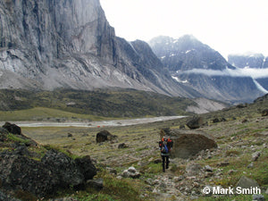
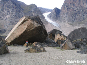
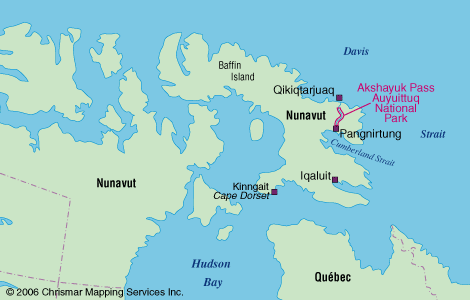
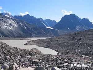
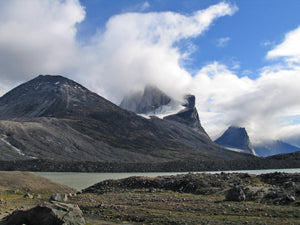
One of the world's greatest long distance backpacking trips takes place through a glacier-edged valley on Baffin Island. The Akshayuk Pass, formerly known as Pangnirtung Pass, is an extraordinary 100-km trek through a land recently vacated by glaciers - though they line the edges of the valley and send fingers of ice creeping into the edges of it. Mountains over 2000 metres high line a route through the finest scenery in North America. In 2004 Outside Magazine voted the Auyuittuq Backpacking trip one of the top "Trips Of A Lifetime". We agree!
Our detailed (no comparable map exists) topographic map of the Pass from end to end plus points of interest, emergency facilities, glaciers with amount of recession, glacial streams, moraines, suggested route and extraordinary vegetation and landscape detail, PLUS text and photos about the area including natural & human history, park facilities, route suggestions, getting to the area, permits and procedures, recommended equipment, weather, safety concerns, contact info, and more. We also include a smaller map of the entire park as well as detailed maps of the two towns (Pangnirtung and Qikiqtarjuaq) closely associated with the route - even though they are many kilometres away you will go through at least one of them on your plane/boat journey. Even a mini-Inuktitut lesson. It's the ideal guide! And made by people who have actually been there (as is the case for all our Adventure Maps®) - we explored the entire Pass during our lengthy field survey visit.
In a land not without its hazards, this Adventure Map®, which has been adopted by the Park as an official map and safety guide, is an essential tool for planning the logistically challenging trip, and for the 5 to 12 day trip itself. Various routes are possible, with numerous sites well worth seeing along the way.
–––––
Note: If you are planning to ONLY walk or ski the Pass, and go nowhere else in the larger Park (which is difficult to access), then you will NOT need any other maps besides The Adventure Map®. For this route, both the federal National Topographic Series (NTS) 1:250,000 scale maps and 1:50,000 maps are outdated and incomplete coverage. Plus you'll need buy a lot of NTS maps to cover the same area shown on just this one Chrismar Adventure Map®.
Additional Info
Area Features:
Extraordinary backpacking/ski destination, 100km-long glacial valley crossing a portion of Baffin island in northern Canada, minimal facilities (emergency shelters), remote access by boat (or in winter by ski), challenging physical requirements for some routes, self-sufficiency required, extraordinary scenery, little wildlife, popular extreme rockclimbing destination, clean air and water, fascinating northern culture in access towns of Pangnirtung and Qikitarjuaq.
Nearest Towns:
Pangnirtung - 85km by boat or land to south
Qikitarjuaq (Broughton Island) - 32km by boat to north
Iqaluit - 300km by air to southwest
Access Options:
Somewhat complex (but well worth it): fly to Iqaluit, then fly to Pangnirtung (south end of route) or continue on by plane to Qikitarjuaq (north end of route).
If hiking or skiing from the south end of the Pass north to Summit Lake and back, then you will need to take an outfitters boat or hike 85km to Overlord at the south end of Pass, and go back to Pangnirtung the same way when your trip through the Pass is complete. In winter you'll take a snowmobile or ski.
If hiking or skiing from the north end of the Pass all the way to the south end, then you will need to take an outfitters boat 32km from Qikitarjuaq (also known as Broughton Island) to the north end of Pass. Once you reach the south end of the Pass you'll take a boat or hike further south to Pangnirtung. In winter you'll take a snowmobile or ski to and from the ends of the Pass.
For More Info:
Contact Auyuittuq National Park at 867-473-2500. They can help with a current list of licensed outfiitters, permit costs, current trail conditions, etc. You're also quite welcome to call Chrismar at 905-852-6151 to order a map and for trip planning assistance.